Explore the world with tourHQ

8-Day Mount Kilimanjaro Trek Via Lemosho Route

Description
Approach Kili from the west with the help of the Lemosho Route! It is a difficult and long route, but one that most reputable Kili outfitters favour due to its smaller crowds, scenic variety and high success rates. Experience the incomparable natural beauty on this trek to Mount Kilimanjaro in just 8 days!
Highlights
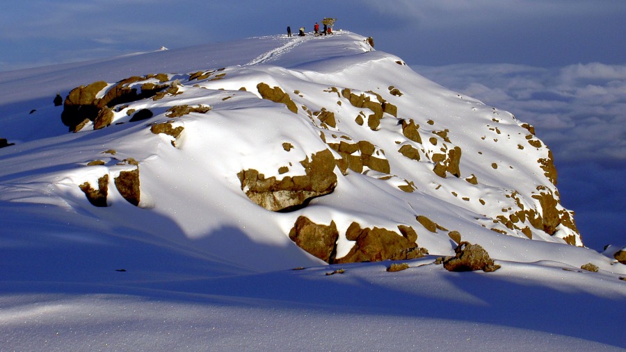
- Admire the magnificent views of Kilimanjaro Peak
- Summit at Uhuru Peak, the highest point in Africa
- Walk along the forest trails to Mti Mkubwa campsite
Itinerary Expand All Collapse All
-
Day 1: Lemosho Glades to Mti Mkubwa (Big Tree) Camp expand_more
Depart Moshi for Londorossi Gate, which takes about 4 hours, and complete the entry formalities.
Drive to the Lemosho trailhead (another hour to reach the trailhead) with your Kilimanjaro trekking guide.
Upon arrival at trailhead, eat lunch, then commence through undisturbed forest which winds to the first campsite.
Elevation (ft): 6,825ft to 9,100ft
Distance: 7 km
Hiking Time: 3-4 hours
Habitat: Rain Forest
-
Day 2: Mti Mkubwa to Shira Camp 1 expand_more
Continue on the trail leading out of the forest and into a savannah of tall grasses, heather, and volcanic rock draped with lichen beards.
As you ascend through the lush rolling hills and cross several streams, reach the Shira Ridge before dropping gently down to Shira 1 camp. The view of Kibo from across the plateau is amazing.
Elevation (ft): 9,100ft to 11,500ft
Distance: 8 km
Hiking Time: 5-6 hours
Habitat: Moorland
-
Day 3: Shira Camp 1 to Shira 2 to Moir Hut expand_more
Explore the Shira plateau for a full day. It is a gentle walk east toward Kibo’s glacier peak, across the plateau which leads to Shira 2 camp on moorland meadows by a stream.
Continue to Moir Hut, a little-used site on the base of Lent Hills. A variety of walks are available on Lent Hills making this an excellent acclimatisation opportunity. Shira is one of the highest plateaus on earth.
Elevation (ft): 11,500ft to 13,800 ft
Distance: 14 km
Hiking Time: 5-7 hours
Habitat: Moorland
-
Day 4: Moir Hut to Lava Tower to Barranco Camp expand_more
From the Shira Plateau, continue to the east up a ridge, passing the junction towards the peak of Kibo.
As you continue, change the direction to the South East towards the Lava Tower called the "Shark's Tooth."
Shortly after the tower, come to the second junction which brings you up to the Arrow Glacier at an altitude of 16,000ft.
Continue down to the Barranco Hut at an altitude of 13,000ft.
Rest, enjoy dinner, and overnight.
Elevation (ft): 13,800ft to 13,000ft
Distance: 7 km
Hiking Time: 4-6 hours
Habitat: Semi Desert
-
Day 5: Barranco Camp to Karanga Camp expand_more
After breakfast, leave Barranco and continue on a steep ridge passing the Barranco Wall, to the Karanga Valley campsite. This is a short day meant for acclimatisation.
Elevation (ft): 13,000ft to 13,100ft
Distance: 5 km
Hiking Time: 4-5 hours
Habitat: Alpine Desert
-
Day 6: Karanga Camp to Barafu Camp expand_more
After breakfast, leave Karanga and hit the junction which connects with the Mweka Trail.
Continue up to the Barafu Hut. At this point, you have completed the South Circuit, which offers views of the summit from many different angles.
Make camp, rest, enjoy dinner, and prepare for the summit day. The two peaks of Mawenzi and Kibo are to be seen from this position.
Elevation (ft): 13,100ft to 15,300ft
Distance: 4 km
Hiking Time: 4-5 hours
Habitat: Alpine Desert
-
Day 7: Barafu Camp to Summit to Mweka Hut expand_more
Very early in the morning (midnight to 2 am), continue your way to the summit between the Rebmann and Ratzel glaciers. You head in a northwesterly direction and ascend through heavy scree towards Stella Point on the crater rim. This is the most mentally and physically challenging portion of the trek.
At Stella Point (18,600 ft), stop for a short rest and will be rewarded with the most magnificent sunrise you are ever likely to see (weather permitting). From Stella Point, you may encounter snow all the way on your 1-hour ascent to the summit.
At Uhuru Peak, you have reached the highest point on Mount Kilimanjaro and the continent of Africa. Faster hikers will see the sunrise from the summit.
From the summit, make your descent continuing straight down to the Mweka Hut camp site, stopping at Barafu for lunch. You will want gaiters and trekking poles for the loose gravel going down. Mweka Camp is situated in the upper forest, and mist or rain can be expected in the late afternoon.
Later in the evening, enjoy your last dinner on the mountain and a well-earned sleep.
Elevation (ft): 15,300ft to 19,345ft (and down to 10,000ft)
Distance: 5 km ascent / 12 km descent
Hiking Time: 7-8 hours ascent / 4-6 hours descent
Habitat: Arctic
-
Day 8: Mweka Camp to Moshi expand_more
After breakfast, continue the descent down to the Mweka Park Gate to receive your summit certificates. At lower elevations, it can be wet and muddy. Gaiters and trekking poles will help.
From the gate, continue another hour to Mweka Village.
Meet up with the vehicle at Mweka village to drive you back to the hotel in Moshi.
Elevation (ft): 10,000ft to 5,400ft
Distance: 10 km
Hiking Time: 3-4 hours
Habitat: Rain Forest
What's Included
Transfer from/to Kilimanjaro International Airport
Hut or camping fees
All park fees
Salary for Kilimanjaro crew (Guide(s), Porters & Cook)
English-speaking Kilimanjaro guide
Rescue fees
Three meals per day (breakfast, lunch, dinner & drinking water)
Two night's accommodation (one night before the climb and one night after the climb) B/B basis
Tent, foam sleeping pads, cooking equipment and eating utensils
Oxygen cylinder and Ox-meter
All government tax (VAT)
What's Excluded
Tip for crew (guide(s), porters & cook)
Personal climbing equipment (however equipment is available for rent)
Lunch and dinner at the hotel
Extra personal needs (cigarettes, alcoholic drinks, etc.)
Meeting Point
Moshi, Tanzania
Cancellation Policy
For cancellations upto 2 days before the tour -
Refund of 80% of the tour price.Price Details
| Adult | |
| 1 To 10 | USD 1865 Per Person |
This is a group tour | |