7-Day Climbing Expedition at Mount Kilimanajro via Machame route


Highlights
Moshi, Mount Kilimanjaro, Machame, Mount Meru
Locations Covered
Moshi, Mount Kilimanjaro, Machame, Mount Meru
trekking, climbing, camping
Private Tour
7 Days
Medium
English
Description
Sign up for a fun and adventurous 7-day trek to Mt Kilimanjaro, the highest mountain in Africa. Trek through the Machame route, also known as the "Whiskey" route, which is the most popular route on Kilimanjaro because of its scenic beauty. Climb the uphills, witness the scenic view of Mount Meru, and reach Uhuru Peak, the highest point of Kilimanjaro. Spot the high-altitude plants, like Scenecio Kilimanjari and Lobelia Deckenii, and be rewarded with the most magnificent sunrise you are ever likely to see coming over Mawenzi Peak.
Itinerary
-
Day 1: Machame Gate to Machame Camp
- Meet the tour guide, who will pick you up from the airport.
- Drive from Moshi to the Machame Gate takes about 1 hr. The journey passes through the village of Machame, located on the mountain's lower slopes.
- Leave the park gate, and walk through the dense rainforest on a winding trail up a ridge until we reach the Machame Camp.
Elevation: 5,380 ft to 9,350 ft
Distance: 11 km/7 miles
Hiking time: 5-7 hours
Habitat: Rainforest -
Day 2: Machame Camp to Shira Cave
- Wake up and get breakfast. Proceed hiking for the second day, where you will trek several uphills, where there are several viewpoints to see the plains and forests below, Kibo peak above, and Mount Meru, the second highest mountain in Tanzania.
- Reach the higher altitude, where you will notice changes in vegetation, and the trees diminish in size, giving way to Kilimanjaro's famous high-altitude plants, Scenecio Kilimanjari and Lobelia deckenii.
Elevation: 9,350 ft to 12,500 ft
Distance: 5 km/3 miles
Hiking time: 4-6 hours
Habitat: HeathNote: This is the shortest day but a steeper one.
-
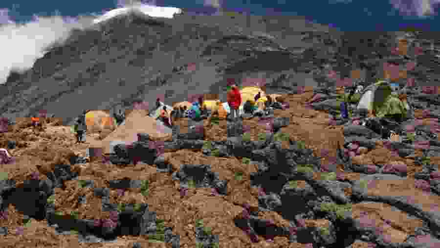
Day 3: Shira Cave to Lava Tower; down to Barranco Camp
- Continue to the east up a ridge and then head southeast towards the Lava Tower – a tall volcanic rock formation.
- Descend to Barranco Camp through the strange but beautiful Senecio Forest to an altitude of 13,000 ft. Although you begin and end the day at the same elevation, the time spent at a higher altitude benefits acclimatization.
Elevation: 12,500 ft to 15,190 ft down 13044ft
Distance: 10 km/6 miles
Hiking time: 6-7 hours
Habitat: Alpine Desert -
Day 4: Barranco Camp to Karanga Camp
- Begin the day by descending into a ravine to the base of the Great Barranco Wall.
- Climb the non-technical but steep, nearly 900 ft cliff. We cross a series of hills and valleys from the top of the Barranco Wall until we descend sharply into Karanga Valley. One steeper climb up leads us to Karanga Camp. (This is a shorter day meant for acclimatization.)
Elevation: 13,044 ft to 13,106 ft
Distance: 5 km/3 miles
Hiking Time: 4-5 hours
Habitat: Alpine Desert -
Day 5: Karanga Camp to Barafu Camp
- Leave Karanga and hit the junction which connects with the Mweka Trail.
- Continue up to the rocky section of Barafu Hut. At this point, you have completed the Southern Circuit, which offers views of the summit from many different angles.
- Make camp, rest and enjoy an early dinner to prepare for the summit day. The two peaks of Mawenzi and Kibo are viewable from this position.
Elevation: 13,106 ft to 15,331 ft
Distance: 4 km/2 miles
Hiking time: 4-5 hoursHabitat: Alpine Desert
-
Day 6: Barafu Camp to Uhuru Peak; descent to Mweka Camp
- Begin hiking the summit early in the morning (around midnight). This is the most mentally and physically challenging portion of the trek. The wind and cold at this elevation and time of day can be extreme.
- Ascend in the darkness for several hours while taking frequent, short breaks. Near Stella Point (18,900 ft), you will be rewarded with the most magnificent sunrise you are ever likely to see coming over Mawenzi Peak.
- Arrive at Uhuru Peak- the highest point on Mount Kilimanjaro and the continent of Africa. From the summit, we now descend, continuing straight down to the Mweka Hut camp site, stopping at Barafu for lunch. The trail is very rocky and can be quite hard on the knees; trekking poles are helpful. Mweka Camp is situated in the upper forest, and mist or rain can be expected in the late afternoon. Later in the evening, we enjoy our last dinner on the mountain and a well-earned sleep.
Elevation: 15,331 ft to 19,341 ft descent to 10065ft
Distance: 18 km/10 miles
Hiking Time: 13-14 hours
Habitat: Arctic -
Day 7: Mweka Camp to Mweka Gate
- Continue the descent to Mweka Gate and collect the summit certificates. At lower elevations, it can be wet and muddy. A vehicle will meet us at Mweka gate to drive us back to the hotel in Moshi.
Elevation: 10,065 ft to 5,380 ft
Distance: 10 km/6 miles
Hiking Time: 3-4 hours
Habitat: RainForest
What's Included
What's Excluded
Know Before You Go
What To Bring
Meeting Point
Cancellation Policy
-
For cancellations within 24 hours before the tour -
Refund of 50% of the tour price.
Price
| Adult | |
|---|---|
| 1 to 20 | /person |
| Child | |
| 1 to 20 | /person |
|
This is a private tour |
|