12-Day Manaslu Circuit Trek
Highlights
Kathmandu
nature, trekking, cultural
Private Tour
12 Days
Medium
English
Description
Join us on a thrilling 12-day Manaslu Circuit Trek, starting from Soti Khola. Trek through Sal forests, terraced ridges, and waterfalls. Explore Tibetan villages and ancient monasteries, and immerse in their rich culture. Marvel at panoramic mountain views and cross the challenging Larkya La Pass.
Itinerary
-
Day 1: Drive from Kathmandu to Soti Khola
Today, you will head out to the starting point of your trek, i.e., Soti Khola. You will take a bus from Kathmandu to Soti Khola. The route of the bus takes you along the Prithvi Highway. The road takes you through the middle hills till Malekhu. From Malekhu, a 30km road takes you north along the Trishuli River as you head towards Dhading Besi. A further 35-kilometer drive along a dirt road leads you to Arughat. As the road winds up to Gola Bhanjyang, you can see panoramic views of Ganesh, Baudha, and Manaslu Himal. A further 3 hours of a ride leads you to Soti Khola. The bus ride to Soti Khola is 8-9 hours.
-
Day 2: Trek from Soti Khola to Maccha Khola
You will start your trekking journey today. The initial portion of today’s trek takes you along a gradual uphill through beautiful Sal forests. You will then walk past forested and terraced ridges and numerous waterfalls. At times, the trail also narrows. You might also find yourself clinging to the sides of cliffs sometimes. The trail then descends as you walk past rice paddies before climbing to Labubesi (885m/2,800ft). From the village of Labubesi, you will trek to a suspension bridge called Nauli Khola. You will descend to gravel banks along the river before hiking gently up to Machha Khola village (900 meters). The trek from Soti Khola to Machha Khola is 6-7 hours long.
-
Day 3: Trek from Maccha Khola to Jagat
After breakfast, you will head out on a 6-7 hour trekking journey to Jagat (1410 meters). After crossing Machha Khola, you will trek gently up to the tiny village of Khorla Bensi. From there, you will reach the natural hot springs at Tatopani. This trail is also quite challenging. After crossing a short forested path, you will reach a single teahouse at Doban. Above the village of Dobhan, the Budhi Gandaki River descends rather impressively to a series of rapids. The river is quite calm beyond this steep slope. A further trek from Dobhan leads you to Lauri, where you will cross the river on a suspension bridge. Finally, you will climb on a high path to the fields of Jagat, where you will spend your night.
-
Day 4: Trek from Jagat to Deng
After breakfast at a teahouse in Jagat, you will embark on your trekking journey. A gentle uphill trek followed by a trek along level fields takes you to a suspension bridge over the Budhi Gandaki. After crossing this suspension bridge, you will arrive at Philim. Philim is a large Gurung village home to small serene monasteries, stupas, and prayer flags. You will have your lunch in Philim. After lunch, you will trek through a flat, levelled path. This path is inside pine and rhododendron forests. During the trek, you will cross several bridges that overlook quaint villages afar. After trekking for 6-7 hours from Jagat, you will arrive at Deng (1080 meters). Deng is home to a few houses. You can also enjoy an amazing waterfall lying at a small distance from Deng. This agricultural village is famous for its potatoes, buckwheat, barley, wheat, cabbage, and spinach.
-
Day 5: Trek from Deng to Namrung
The trail from Deng takes you along a winding path to Rana. You will get to a log bridge after trekking past a series of uphills and downhills. After crossing a tributary from the bridge, you will get to an isolated water mill. Then, you will descend gently along the trail to Bihi Phedi, which lies high above the river. Beyond Bihi Phedi, the trail descends as you cross the Serang Khola. Then, you will trek along a winding path that shapes up like an S. The path lies between sheer basalt walls. You can also see huge rocky crags to the right. You will also have splendid views of the waterfall above the maize and wheat fields. As you trek towards the northeast direction, the valley broadens. After trekking past a bridge and mani stone walls, you will reach the attractive village of Ghap (2,250m/ 7,382ft). Past the village of Ghap, you will trek through bamboo, rhododendron and oak forests. On some days, you can also see birds like Impeyan pheasant (also known as Himalayan Monal). This trail is above the steep descent of the river. You will trek to the north bank for a short duration. Then, you will head back towards the southern bank after crossing a bridge. After trekking for one hour from the bridge, you will reach Namrung. Namrung also has a police checkpoint for permits. Just before you get to Namrung, the trail overlooks Tum Khola from Tibet. This adds to the volume of water in Budhi Gandaki in the confluence. The trek from Deng to Namrung (2630 meters) is 6-7 hours long.
-
Day 6: Trek from Namrung to Samagaon
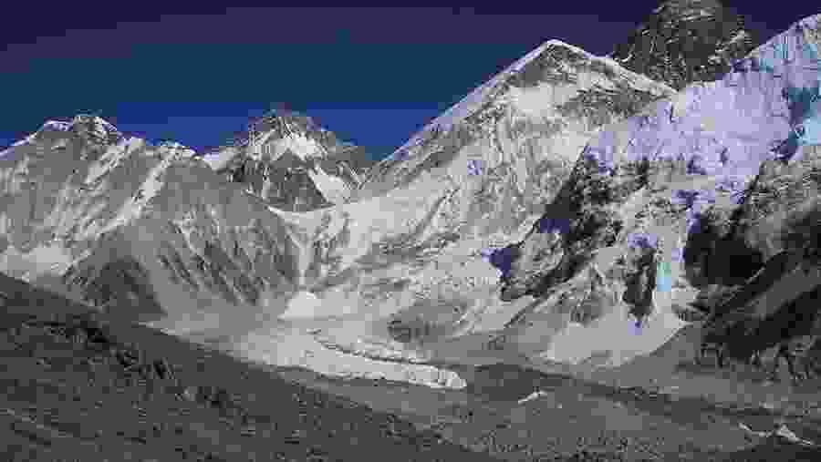
Namrung is a Tibetan village and serves as an entrance to Upper Nupri. As you trek past a mix of forest and barley fields, you will reach Lihi. You can see impressive chortens as well as great views of Himal Chuli (7,893m/25,897ft) and Ganesh Himal. The trail then descends before entering a valley as you cross the Hinang Khola. After crossing the Hinanag River on a bridge, you will trek along a steep uphill to a chorten, which offers spectacular views of Ngadi Chuli (7,873m/25,831ft). As you trek further up a steep ridge, you will reach Lho. You can also visit a large monastery called Ribung Monastery in Lho. You will then trek down a steep uphill before you reach the Damonan Khola tributary. After trekking past a plateau, you will get to Shyala village (3,520m/11,549ft). Shayala overlooks many beautiful peaks like Himal Chuli (7,893m/25,897ft), Peak 29 (Ngadi Chuli, 7,873m/25,831ft); and Manaslu (8,156m/26,760ft). As you continue trekking, you will get to a bridge over Numla Khola. The trail then takes the left of Pungyen Gompa. After trekking for 6-7 hours from Namrung, you will get to Samagaon (3530 meters). Kargyu Chholing Monastery stands against a forested moraine around the edge of this village. From Samagaon, you can only see the upper sections of Manaslu and the Naike ridge.
-
Day 7: Trek from Samagaon to Pungyen Gompa, then Back to Samagaon
Today, you will explore the village of Samagaon, the regional center of Nupri. You will also learn about the region's culture and architecture. Only potatoes and barley flourish in the short summers at this altitude. Most of the people in this village weave clothes from sheep or Tibetan imported wool. They are also involved in manufacturing hooked rugs for trade with Tibet. You will visit the Labrang (Lama's Place) Gompa and the Kargyu Chholing Monastery in Samagaon. The history of these monasteries dates back some 500 years ago. Many people ascribe the history of these monasteries to its earlier Tibetan settlers. The monastery has impressive wooden carvings.
All in all, there are eight temple buildings. The largest of them is the Pemba Chholing Gompa, home to an impressive statue of Guru Rinpoche. A gentle hike past the monastery leads you to Birendra Tal (3,450m/11,319ft). This lake lies below the Manaslu Glacier. You can also trek for close to 3 kilometres to get to a hilltop or a stony beach that offers wonderful views of Manaslu. You can also follow a trail towards Samdo to a bridge over the stream from the lake. After trekking for 5-6 hours, you will get to Manaslu Base Camp. You can also trek to Pungyen Nunnery (3,870m/12,697 ft) above the Pungyen Glacier. You can get sumptuous views of the Nadi ridges and Manaslu from near the gompa.
-
Day 8: Trek from Samagaon to Samdo
The initial part of today’s trek descends towards Budhi Gandaki. The trail is in the north towards the lake. You will walk along the Base Camp trail as you encounter several mani walls as the valley widens. The trek is relatively easy and lies a shelf above the river. You will walk past the forests of juniper and birch which surround Kermo Kharka. The trail then descends to a wooden bridge as you cross the Budhi Gandaki River. Then, you will trek along a steep uphill to a ridge above the confluence of Budhi Gandaki and Mayol Khola. You will encounter a stone arch and fields before you get to the village entrance. Although the place is attractive, it is primarily a yak and goat herding area. The village only turned out as a settlement in the late 1950s when Tibetans fled Tibet. As you trek past these fields, you will get to several sets of flags on a high ridge. Here, you can catch superb panoramic views of Samdo Peak (6,335m/20,785ft) and its glacial basin, the Sama Valley, Manaslu range, Syacha Glacier, Dharamsala, and Larkya La pass. After trekking for 4-5 hours from Samagaon, you will reach Samdo (3860 meters). Samdo is the last village before Gho in the Manang District. Only informal kharkas (with lodges) lie between these villages.
-
Day 9: Trek from Samdo to Dharamsala
You will trek past the fields in the northern village as you cross the Budhi Gandaki for the final time. This will take place at the Larkya Bazaar site. The river's flow takes it to the Pana Danda Valley in the north. You will then take the westward trail. You will trek past grassy slopes with scrub juniper, rhododendron and lichen-covered granite. This trail is just above the Syacha Khola Valley. Along the way, you can also see the origin of Syacha Glacier, which descends from the Manaslu North ridge. The trail works heads towards the Larkya Glacier. After trekking past the Larkya La Phedi, you will reach Dharamsala (4460 meters). Today’s trek from Samdo to Dharamsala is 4-5 hours long. A short walk from your guesthouse will take to a place with better views of the Larke (6,249m/20,503ft) and Naike (6,291m/20,641ft) peaks.
-
Day 10: Trek to Bhimthang via Larkya La Pass
Today, you trek for 3-5 hours to ascend 800m/2,600ft to get to Larkya La Pass (5160 meters). You will descend for 3-4 hours, losing 1,500m/4,900 in altitude to get to Bimthang(3720 meters). If the wind blows, it can get really cold along the way. You have to be extra careful if you encounter ice and snow along the way. The trekking trail from Dharamsala takes you along a gentle ascent to a ridge. Then will be a long, gentle climb to the moraine. The trail along the northern moraine of the Larke Glacier is not quite steep. However, the trek is quite long and rocky. So you might find this a bit challenging. From the glacier, you can see the Larke Peak (Larke Himal) and Pawar Peak (Cheo Himal) on the south and north of the glacier, respectively. From the pass, you will trek uphill to an ablation valley. The trail then drops to the first of four small scattered frozen lakes. You will get to the first set of summit flags as you trek uphill to the glacial moraine from the left. After spending some time in Larkya La pass, you will start your descent from these prayer flags. The trail descends steeply from the moraine. Then, you will get to a set of steep zigzags until you reach Dangboche Kharka (4,450m/14,600ft). The trail from Dangboche Kharka is not steep—the trail winds along the lateral moraine of the Salpudanda/Bimthang glacier before getting to Bimthang Valley.
-
Day 11: Trek from Bhimthang to Dharapani
Bhimthang is a beautiful settlement that gives you views of the Kechakyu Himal on the north and Manaslu’s northeast face. Bhimthang serves as a settlement for the people of Samdo village in the summer season. It was also an important trading post before the border to Tibet closed down. It was also a center of the Tibetan Khampa warriors around 1970. Today’s trek begins as you walk past the Bimthang Plain. You will descend along a trail to cross the stony glacier before heading up a moraine to enter the rhododendron and pine forest. All along this route, you will get wonderful views of Larke, Manaslu, Nadi and Chuli Himals. As you descend, you will reach Hompuk and Sangura Kharka before reaching Karche. From Karche, you will trek past terraced fields and a steep uphill until you reach Gho. The trail from Gho takes you through farmlands to Tilje (2,300m/7,546ft). From there, you will descend rapidly towards the Marsyangdi Valley in Thonje (1,965m/6,447ft). You will then join the new road along the main Annapurna Circuit route in Dharapani(3560 meters). Today’s trek is 5-6 hours long.
-
Day 12: Drive from Dharapani to Kathmandu or Pokhara
Today, you will head back to Kathmandu. You will follow the Prithvi Highway en route to Kathmandu. To reach our destination, we need to drive for about 7-8 hours by jeep and 9-10 hours by local bus. You can view natural waterfalls, rice fields, local houses, forests, and streams on the way.
What's Included
What's Excluded
Know Before You Go
What To Bring
Meeting Point
Cancellation Policy
-
For cancellations upto 2 days before the tour -
Refund of 80% of the tour price.
Price
| Adult | |
|---|---|
| 1 to 12 | /person |
| Child | |
| 1 to 12 | /person |
|
This is a private tour |
|